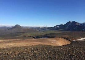
Vonarskarð
Vonarskarð is notable among other things for the fact that it is the site of the water divide between north and south Iceland, and where the sources of both Skjálfandafljót and Kaldakvísl can be found. In the western part of Vonarskarð there is a geothermal high-temperature area, with nearly all the phenomena that are known to exist in such areas. This is a remote place, and although some believe that the settler Gnúpa-Bárður went through the pass during the Age of Settlement, the first recorded instance of anyone travelling in the area was about 1839. There is no road for cars that leads to Vonarskarð, but it can be reached on foot from Kolufell, Gjósta and Nýidalur.
Discover
Hiking trails in Vonarskarð

Svarthöfði - Vonarskarð
A hike over the pass between Svarthöfði and Kolufell, then along the slopes of Skrauti into Snapadalur and to the Hverahlíð high temperature geothermal area. Magnificent landscape, rhyolite screes, alpine vegetation and high temperature geothermal area. Attention: There is no cell coverage or tetra coverage in Vonarskarð.

Nýidalur - Vonarskarð - Nýidalur
The trail follows Mjóháls ridge into Vonarskarð and leads to the Hverahlíð high temperature geothermal area which has varied geothermal formations. From Mjóháls there is a magnificent view of Nýidalur and Tungnafellsjökull.

Tvílitaskarð
A circular trail around Kolufell. View over Vonarskarð, varied hyaloclastite (móberg) and rhyolite formations, peaceful mountain lake.

Gjósta - Vonarskarð
The trail follows Gjóstukleif, down into Vonarskarð and on to the Hverahlíð high temperature geothermal area. Views of Vonarskarð and the water-shed, barren landscape and high temperature geothermal area. Warning no cell or tetra coverage in Vonarskarð.