
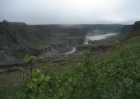
Hólmatungur - Dettifoss
The trail is from Hólmatungur to Dettifoss. The trail is one of three parts for hiking the whole Jökulsárgljúfur, 32 kilometers in total.
Ásbyrgi-Dettifoss: Tengdar gönguleiðir
Ásbyrgi to Dettifoss - Canyon Trail
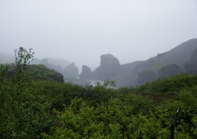
The trail between Ásbyrgi and Dettifoss is 32 kilometers through Jökulsárgljúfur canyoun. Points of interest Jökulsárgljúfrum. Hiking up along the Jökulsárgljúfur canyon, from the luxuriant Ásbyrgi to the barren but magnificent environment around Dettifoss, is a unique experience for every hiker. The diversity of the landscape is unique and captures the eye at every footstep: tremendous gorges, quiet ponds, clear springs, rough river, luxuriant forests and bare gravel plains. Two days are recommended for the whole hike. On the route there are no cabins and it is only allowed to camp on the park campsites at Vesturdalur and Dettifoss.
Vesturdalur - Hólmatungur
The route between Vesturdalur and Hólmatungur is about 8 km. The only river that has to be waded during the hike, Stallá, is at this section. Stallá is a spring river that flows into the Jökulsá river. The river is shallow and cold, but wading restores tired legs and makes the trip more memorable. The trail is a part of the canyon trail between Ásbyrgi and Dettifoss that is 32 kilometers.
Ásbyrgi - Vesturdalur
From Ásbyrgi to Vesturdalur there are two paths to choose from: One is to follow the rim of Ásbyrgi, and go south along Klappir and Kvíar, just over 12 km. The other route is to go the easterly path, closer to the river, but that route is 13,6 km long. Both routes start at the Visitor Centre in Ásbyrgi. The trail is a part of the canyon trail from Ásbyrgi to Dettifoss, 32 kilometers in total.